
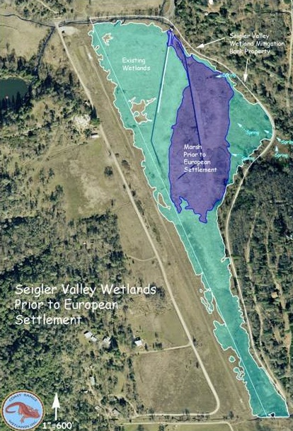
Seigler Valley is underlain by lacustrine clays and occupies the former bed of a montane, Pleistocene lake. Based on current elevations and morphology, the northern end of the valley still supported a remnant marsh 11.4 acres in surface area prior to European settlement. This former marsh habitat is shown in dark blue on the map provided in the figure below. The light blue shown in the figure represents current saturated soils and wetland habitat.
| Following the settlement of the area in the late 1800s and early 1900s, efforts were made to drain the valley for agricultural use. The easternmost drainage ditch shown in Figure 1 was present in the 1940 aerial photo and the site was under cultivation at that time. The downstream end of this ditch consists of a hand-cut, stone-lined channel covered with large flagstones and buried to a depth of one-to-two feet. The structure appears to predate the widespread use of mechanical equipment and steel culverts. By 1942, the agricultural operation had ceased. Based on written inter-views with the people who owned the property be-tween the early 1940s and 2000, Hobergs Airport was constructed along the western edge of the valley in 1948 in association with the Hobergs Resort, a well known destination resort between the early 1900s and about 1970. The runway was constructed upon a filled causeway along the western edge of the valley and is visible along the western edge of the wetland bank property. A 1952 aerial photo of this site shows the raised runway and the two western drainage ditches which were apparently constructed between 1948 and 1952.
|
The runway was abandoned in the early 1970s and is formally abandoned through FAA regulation. Since that time the property has lain fallow and has been used for livestock grazing.